-
Use Cases
-
Resources
-
Pricing
The Global Positioning System (GPS) is a satellite-based navigation network developed by the United States Department of Defense. Its origins trace back to early satellite tracking experiments like Sputnik in 1957 and the Navy's Transit system. Officially launched as a military program in the 1970s, GPS became fully operational in 1995 and was later opened for civilian use, transforming transportation, science, commerce, and everyday life around the world. More Less
Oct 4, 1957
% complete
The Soviet Union launched Sputnik 1, the first artificial satellite. Scientists at MIT tracking its radio signals discovered they could determine the satellite's position from the Doppler shift of its signal — an insight that later inspired the idea that a known satellite position could be used to fix a receiver's location on Earth.
Image source: Sputnik 1
Jan 1, 1959
% complete
The US Navy developed Transit, the first operational satellite navigation system. Using Doppler measurements from a small constellation of satellites, Transit allowed submarines and ships to fix their positions at sea, though fixes could take many minutes and were not continuous.
Image source: Transit (satellite)
Jan 1, 1964
% complete
Naval Research Laboratory scientist Roger Easton pioneered the Timation program, which demonstrated that precise atomic clocks aboard satellites could enable passive ranging for navigation. This time-of-arrival concept became the technical foundation of GPS.
Image source: Roger L. Easton
Jan 1, 1964
% complete
The Aerospace Corporation conducted Project 621B for the US Air Force, studying how satellites using pseudorandom noise signals could provide three-dimensional positioning for aircraft. Its work on spread-spectrum signaling shaped GPS's signal design.
Image source: Global Positioning System
May 31, 1967
% complete
The Navy launched Timation 1, carrying stable quartz clocks into orbit to test time-transfer and passive ranging techniques. The experiments proved that precise timing from space was feasible, validating a core principle of future GPS architecture.
Image source: Timation
Apr 17, 1973
% complete
Deputy Secretary of Defense William Clements directed the consolidation of competing military satellite navigation efforts into a single Joint Program Office led by the Air Force. Colonel Bradford Parkinson was named program director, unifying the Navy's Timation concepts with Air Force designs.
Sep 13, 1973
% complete
Over Labor Day weekend in 1973, Bradford Parkinson and his team finalized the baseline GPS design: about 24 satellites in medium Earth orbit broadcasting spread-spectrum signals with atomic clocks. The concept was formally approved by the Defense Department Acquisition Review Council in December 1973.
Image source: Global Positioning System
Jan 17, 1991 - Feb 28, 1991
% complete
During the Gulf War, coalition forces used hastily fielded GPS receivers to navigate featureless desert terrain, enabling the famous 'left hook' flanking maneuver. The war showcased GPS's battlefield value and accelerated procurement and development.
Image source: Gulf War
Dec 1, 1993
% complete
With 24 operational satellites in orbit providing continuous global coverage, the Defense Department declared GPS to have Initial Operational Capability. The constellation could now deliver standard positioning service worldwide around the clock.
Apr 27, 1995
% complete
The US Air Force declared GPS fully operational after completing extensive testing of the 24-satellite constellation, ground control segment, and user equipment. The declaration confirmed the system met all military requirements for precision navigation and timing.
Jun 23, 1977
% complete
The Navigation Technology Satellite 2 (NTS-2), built on the Timation heritage, carried the first cesium atomic clock into orbit and transmitted pseudorandom noise signals compatible with the planned GPS architecture, proving the system's key technologies in space.
Feb 22, 1978
% complete
NAVSTAR 1, the first of eleven developmental Block I GPS satellites, lifted off from Vandenberg Air Force Base aboard an Atlas F rocket. These prototype satellites allowed engineers to test the full GPS concept, including signal structure and orbit determination.
Image source: GPS satellite blocks
Dec 1, 2005
% complete
The first GPS IIR-M satellite began transmitting L2C, the second dedicated civilian signal. L2C improves accuracy and reliability for consumer and commercial users, particularly in challenging environments where signals are weak or reflected.
Image source: GPS signals
Sep 13, 2007
% complete
The Air Force activated the new GPS Operational Control Segment at Schriever Air Force Base, replacing 1970s-era mainframe computers. The modernized ground system improved monitoring accuracy and prepared infrastructure for new GPS signals.
May 3, 2008
% complete
The US Air Force selected Lockheed Martin to build the GPS III series, featuring a more powerful signal, better anti-jamming capability, and a new international civil signal interoperable with Galileo. GPS III represents the most significant upgrade since the original design.
May 28, 2010
% complete
Boeing-built GPS IIF SV-1 entered service carrying improved atomic clocks and broadcasting the new L5 civil signal designed for safety-of-life applications like aviation. The IIF block marked a major step in GPS modernization.
Image source: GPS Block IIF
Dec 23, 2018
% complete
Vespucci, the first GPS III satellite, launched aboard a SpaceX Falcon 9 rocket. It delivers roughly three times greater accuracy and up to eight times stronger anti-jamming performance than earlier blocks, beginning the next era of GPS capability.
Sep 1, 1983
% complete
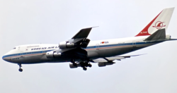
After Soviet fighters shot down KAL 007 when it strayed into restricted airspace due to a navigation error, President Ronald Reagan announced that GPS would be made available for civilian use once operational, dramatically expanding the system's envisioned role beyond the military.
Image source: Korean Air Lines Flight 007
Jan 1, 1989
% complete
Magellan Systems introduced the NAV 1000, widely regarded as the first commercially available handheld GPS receiver. Priced for consumers, it demonstrated that GPS technology could be miniaturized and sold affordably outside government and military markets.
Image source: Magellan Navigation
Jan 1, 1990
% complete
Garmin, founded in 1989 by Gary Burrell and Min Kao, began selling portable GPS receivers for pilots, hikers, and boaters. Affordable consumer devices brought satellite navigation out of military use and into everyday recreation and travel.
Image source: Garmin
Jan 1, 1990
% complete
Ground reference stations broadcasting corrections allowed differential GPS to correct atmospheric and clock errors, boosting accuracy from meters to centimeters. The technique enabled surveying, precision farming, dredging, and eventually autonomous vehicle development.
Image source: Differential GPS
Jul 4, 1991 - May 1, 2000
% complete
For years the military intentionally degraded civilian GPS accuracy through Selective Availability, introducing clock and ephemeris errors that limited precision to roughly 100 meters. Differential GPS techniques emerged partly to counteract this deliberate error.
Jan 1, 1994
% complete
RTK techniques using carrier-phase measurements delivered real-time centimeter accuracy, revolutionizing land surveying, machine control, and construction. Networks of continuously operating reference stations later extended RTK corrections over wide areas.
Image source: Real-time kinematic positioning
May 1, 2000
% complete
President Bill Clinton ordered the discontinuation of Selective Availability, instantly improving civilian GPS accuracy from about 100 meters to under 10 meters. This policy change unlocked mass-market applications including consumer navigation devices and precision agriculture.
Mar 26, 2002
% complete
The European Union committed to building Galileo, its own global navigation satellite system offering a civilian-controlled alternative to GPS. The decision reflected Europe's desire for independence in critical navigation infrastructure.
Image source: Galileo (satellite navigation)
Jul 10, 2003
% complete
The Federal Aviation Administration commissioned WAAS, a satellite-based augmentation system that provides corrected GPS signals across North America. WAAS enabled aircraft to use GPS for precision approaches, improving aviation safety and efficiency.
Image source: Wide Area Augmentation System
Jun 2, 2007
% complete
China launched the first satellite of its BeiDou-2 system, beginning expansion from a regional service to a global navigation constellation. BeiDou would eventually offer worldwide positioning, navigation, and timing services independent of GPS.
Image source: BeiDou
Jun 29, 2007
% complete
The iPhone's launch, followed by Android devices, embedded GPS chips in billions of pockets. Location-aware apps for mapping, ride-hailing, fitness tracking, and geotagging transformed GPS from a specialized tool into an invisible utility woven into daily life.
Image source: Assisted GNSS
Oct 24, 2011
% complete
After years of decline following the Soviet collapse, Russia completed restoration of its GLONASS constellation to full global coverage with 24 operational satellites, creating a second fully functional global navigation satellite system alongside GPS.
Feb 12, 2020
% complete
Executive Order 13905 on Strengthening National Resilience through Responsible Use of Positioning, Navigation, and Timing Services highlighted GPS jamming and spoofing risks, spurring development of backup timing systems and hardened receivers across critical infrastructure.
Apr 27, 2020
% complete
Twenty-five years after Full Operational Capability was declared, GPS had become essential global infrastructure supporting aviation, banking timestamps, power grids, agriculture, and billions of smartphone users, while modernization efforts continued toward enhanced accuracy and resilience.
Or browse the full history timeline directory, with more than 2,000 topics.
This History of GPS timeline was generated with the help of AI, using information found on the internet.
We work hard to keep these timelines accurate, but mistakes do get through. If you spot one, email us at [email protected] and we'll fix it for future visitors.
Generate yours with AI or build it from scratch, for free.
Export your timeline, add your own events, edit or remove AI-generated events, and much more
No credit card required.
Cancel anytime.
Cancel anytime.
You can create an unlimited number of timelines with up to 10 events on each one, customize how they look, export them to PDF, PNG, PowerPoint, CSV, and Excel, and share them with a link. Paid plans raise the event limit and add features like spreadsheet imports and collaborators.
Yes. You can cancel your subscription from your account page at any time, and you will not be charged again. Your subscription stays active for the rest of the period you already paid for.
Yes. We will email you a reminder before the annual renewal, and we will also email you a receipt.
Yes. You can email us within 15 days of any payment, and we will issue you a full refund.
Check out our pricing docs or send us an email anytime: [email protected].