-
Use Cases
-
Resources
-
Pricing
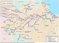
The Amazon River, the largest river in the world by discharge volume, has a rich history spanning millions of years. Formed through dramatic geological shifts, it was home to thriving indigenous civilizations long before European explorers arrived in the 16th century. The river became a vital artery for trade, rubber booms, and scientific exploration, and today it remains central to ecological conservation debates in South America. More Less
Mar 1500
% complete
In March 1500, Spanish conquistador Vicente Yáñez Pinzón became the first documented European to sail up the Amazon River.
Image source: Vicente Yáñez Pinzón
1541
% complete
Gonzalo Pizarro set off in 1541 to explore east of Quito into the South American interior in search of El Dorado, the 'city of gold,' and La Canela, the 'valley of cinnamon.'
Image source: Gonzalo Pizarro
Dec 26, 1541
% complete
De Orellana took about 57 men, the boat, and some canoes and left Pizarro's troops on 26 December 1541, beginning the journey that would take him down the Amazon.
Image source: Francisco de Orellana
1542
% complete
The name Rio Amazonas was reportedly given after native warriors attacked the 16th-century expedition led by Francisco de Orellana, reminding the Spaniards of the fierce female warriors of Greek myth.
Image source: Amazon River
Jun 3, 1542
% complete
After a journey of 600 km down the Napo River, Orellana's men reached a major confluence near modern Iquitos, then followed the upper Amazon, now known as the Solimões, for another 1,200 km to its confluence with the Rio Negro near modern Manaus, arriving there on 3 June 1542.
Image source: Rio Negro (Amazon)
Aug 24, 1542
% complete
The expedition reached the mouth of the Amazon on 24 August 1542, demonstrating the practical navigability of the Great River for the first time by Europeans.
1560
% complete
In 1560, another Spanish conquistador, Lope de Aguirre, may have made the second descent of the Amazon River.
1637
% complete
He arrived in Quito in 1637, and returned via the same route, an important early traversal connecting the Amazon basin with the Andes.
Image source: Pedro Teixeira
1648 - 1652
% complete
From 1648 to 1652, Portuguese Brazilian bandeirante António Raposo Tavares led an expedition from São Paulo overland to the mouth of the Amazon, investigating many of its tributaries, including the Rio Negro, and covering over 10,000 km.
Image source: António Raposo Tavares
1541
% complete
Archaeologists estimate that by the time Spanish conquistador Francisco de Orellana traveled across the Amazon in 1541, more than 3 million indigenous people lived around the Amazon.
1700 - 1850
% complete
Early scientific, zoological, and botanical exploration of the Amazon River and basin took place from the 18th century through the first half of the 19th century.
1743
% complete
Charles Marie de La Condamine explored the river in 1743, contributing important scientific observations about the Amazon.
Image source: Charles Marie de La Condamine
1900 - 2000
% complete
This situation changed dramatically during the 20th century, with expanded development and transformation of the Amazon basin.
2011
% complete
More than 5,600 species were known as of 2011, and approximately fifty new species are discovered each year. The candirú, a parasitic freshwater catfish, is just one of more than 1,200 species of catfish in the Amazon basin.
Aug 2011
% complete
Paralleling the Amazon River is a large aquifer dubbed the Hamza River, flowing far underground. The discovery was made public in August 2011.
Image source: Hamza River
Nov 2012
% complete
Contos continued downstream to the ocean and finished the first complete descent of the Amazon from its newly identified source in November 2012, a journey later repeated by two groups after the news spread.
Image source: Source of the Amazon River
2020 - 2026
% complete
In recent years, the Amazon River has experienced historically low water levels, the lowest in over a century, threatening ecosystems and river communities.
Image source: 2023–2024 South American drought
2022
% complete
In 2022, the region's severe drought led to a devastating increase in water temperatures, reaching 39.1 degrees Celsius, causing the demise of 125 Amazon river dolphins.
Image source: Amazon river dolphin
1700 - 1900
% complete
For most of the 18th–19th centuries and into the 20th century, the Marañón was generally considered the source of the Amazon.
Image source: Marañón River
1707
% complete
Fritz proposed that the Marañón River must be the source of the Amazon, noting on his 1707 map that the Marañón has its source on the southern shore of Lake Lauricocha, near Huánuco. He reasoned it was the largest branch encountered upstream and lay farther west than any other tributary.
1996 - 2008
% complete
Studies published in 1996, 2001, 2007, and 2008 identified the snowcapped 5,597 m Nevado Mismi peak, roughly 160 km west of Lake Titicaca, as the most distant source of the river. The headwaters of the Apurímac River had been considered the basin's most distant source for nearly a century.
Image source: Mismi
Jun 2007
% complete
In June 2007, Guido Gelli, director of science at the Brazilian Institute of Geography and Statistics, told London's Telegraph newspaper that the Amazon could be considered the longest river in the world.
Jul 2008
% complete
In July 2008, the Brazilian Institute for Space Research published a news article claiming that the Amazon River was 140 km longer than the Nile.
2009
% complete
In 2009, a peer-reviewed article concluded that the Nile is longer than the Amazon, stating a length of 7,088 km for the Nile and 6,575 km for the Amazon, measured using satellite image analysis and field investigations to the source regions.
2014
% complete
A 2014 study by Americans James Contos and Nicolas Tripcevich in Area, a peer-reviewed journal of the Royal Geographical Society, identified the most distant source of the Amazon as actually being in the Río Mantaro drainage on the Cordillera Rumi Cruz in Peru, ending nearly a century of consensus around Nevado Mismi.
Image source: Mantaro River
1835 - 1840
% complete
The Cabanagem revolt (1835–1840) was directed against the white ruling class in the Amazon region of Brazil.
Image source: Cabanagem
1850
% complete
The population of the Brazilian portion of the Amazon basin in 1850 was perhaps 300,000, of whom about 175,000 were Europeans and 25,000 were slaves.
Image source: Amazon basin
Sep 6, 1850
% complete
On 6 September 1850, Emperor Pedro II of Brazil sanctioned a law authorizing steam navigation on the Amazon and gave the Viscount of Mauá the task of putting it into effect.
Image source: Irineu Evangelista de Sousa, Viscount of Mauá
1852
% complete
The Viscount of Mauá organised the Companhia de Navegação e Comércio do Amazonas in Rio de Janeiro in 1852; in the following year it commenced operations with four small steamers: the Monarca, the Cametá, the Marajó, and the Rio Negro.
1857
% complete
At first, navigation was principally confined to the main river; even in 1857 a modification of the government contract only obliged the company to a monthly service between Pará and Manaus, a second line making six round voyages a year between Manaus and Tabatinga, and a third making two trips a month between Pará and Cametá.
1860 - 1911
% complete
In the 1860s, approximately 3,000 tons of rubber were being exported annually; by 1911 annual exports had grown to 44,000 tons, representing 9.3% of Peru's exports. Iquitos grew from 200 people in 1851 to 20,000 by 1900.
Image source: Amazon rubber cycle
Jul 31, 1867
% complete
On 31 July 1867, the Brazilian government decreed the opening of the Amazon to all countries, limited to certain defined points: Tabatinga on the Amazon, Cametá on the Tocantins, Santarém on the Tapajós, Borba on the Madeira, and Manaus on the Rio Negro.
Sep 7, 1867
% complete
The Brazilian decree opening the Amazon to international navigation took effect on 7 September 1867.
1874
% complete
The first direct foreign trade with Manaus commenced around 1874, boosting the city's role in the rubber economy.
1896
% complete
Four centuries after the European discovery of the Amazon river, the total cultivated area in its basin was probably less than 65 km², excluding limited and crudely cultivated areas among the mountains at its extreme headwaters.
1900
% complete
By the turn of the 20th century, the exports of the Amazon basin were India-rubber, cacao beans, Brazil nuts, and minor products such as pelts, resins, barks, woven hammocks, bird feathers, live animals, lumber, and gold.
2014
% complete
With a population of 1.9 million people in 2014, Manaus is the largest city on the Amazon.
Image source: Manaus
Or browse the full history timeline directory, with more than 2,000 topics.
This History of the Amazon River timeline was generated with the help of AI, using information found on the internet.
We work hard to keep these timelines accurate, but mistakes do get through. If you spot one, email us at [email protected] and we'll fix it for future visitors.
Generate yours with AI or build it from scratch, for free.
Export your timeline, add your own events, edit or remove AI-generated events, and much more
No credit card required.
Cancel anytime.
Cancel anytime.
You can create an unlimited number of timelines with up to 10 events on each one, customize how they look, export them to PDF, PNG, PowerPoint, CSV, and Excel, and share them with a link. Paid plans raise the event limit and add features like spreadsheet imports and collaborators.
Yes. You can cancel your subscription from your account page at any time, and you will not be charged again. Your subscription stays active for the rest of the period you already paid for.
Yes. We will email you a reminder before the annual renewal, and we will also email you a receipt.
Yes. You can email us within 15 days of any payment, and we will issue you a full refund.
Check out our pricing docs or send us an email anytime: [email protected].