-
Use Cases
-
Resources
-
Pricing
The Mississippi River, one of the world's most significant waterways, has shaped the history, economy, and culture of North America. Flowing over 2,300 miles from Minnesota to the Gulf of Mexico, it served as a vital artery for Native American civilizations, European explorers, steamboat commerce, and modern industrial transport, while also presenting challenges like devastating floods that led to major engineering projects. More Less
5000 BCE
% complete
Native American peoples, including the Ojibwe, Dakota, Choctaw, Chickasaw, and many others, settled along the Mississippi's banks for thousands of years, relying on the river for transportation, food, trade, and spiritual life.
Image source: Mississippi River
1050 - 1350
% complete
The Mississippian culture city of Cahokia rose near present-day St. Louis along the Mississippi River. With tens of thousands of residents and massive earthen mounds like Monks Mound, it was the largest pre-Columbian settlement north of Mexico before its decline by 1350.
Image source: Cahokia
May 1541
% complete
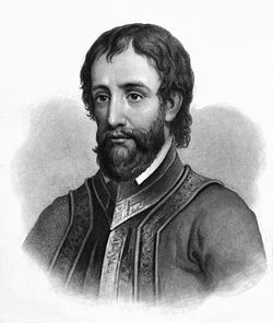
Spanish explorer Hernando de Soto became the first documented European to see the Mississippi River, which his expedition called the Río del Espíritu Santo. De Soto died of fever on its banks in 1542, and his men buried him in the river.
Image source: Hernando de Soto
Jun 1673 - Sep 1673
% complete
French explorers Jacques Marquette and Louis Jolliet paddled from Lake Michigan to the Mississippi and down to the Arkansas River, mapping the river's course and establishing French claims to the Mississippi Valley.
Image source: Jacques Marquette

Apr 1682
% complete
René-Robert Cavelier, Sieur de La Salle, descended the Mississippi to its mouth in the Gulf of Mexico and formally claimed the entire river basin for France, naming the territory Louisiana after King Louis XIV.
Image source: René-Robert Cavelier, Sieur de La Salle
May 1804
% complete
Meriwether Lewis and William Clark departed from Camp Dubois near the confluence of the Missouri and Mississippi Rivers, beginning their transcontinental expedition that built on the strategic importance of America's western waterways.
Image source: Lewis and Clark Expedition
1718
% complete
Jean-Baptiste Le Moyne de Bienville founded New Orleans as the capital of French Louisiana on a crescent of the Mississippi River about 100 miles upriver from the Gulf, making it the vital port linking the river's vast commerce to the sea.
Image source: New Orleans
Sep 3, 1783
% complete
At the end of the American Revolutionary War, Britain ceded its territory east of the Mississippi River to the newly independent United States, while Spain retained control of lands west of the river, making the Mississippi an international boundary.
Image source: Treaty of Paris (1783)
Oct 27, 1795
% complete
Spain granted the United States free navigation of the Mississippi River and right of deposit at New Orleans under Pinckney's Treaty, resolving a critical dispute for American western settlers who depended on the river to ship goods to market.
Image source: Pinckney's Treaty
Dec 20, 1803
% complete
France sold the Louisiana Territory, including both banks of the lower Mississippi and the port of New Orleans, to the United States for $15 million, giving America complete control of the river's navigation and doubling the nation's size.
Image source: Louisiana Purchase
Oct 1811 - Jan 1812
% complete
The steamboat New Orleans completed the first steam-powered voyage from Pittsburgh to New Orleans, inaugurating the steamboat era on the Mississippi that would revolutionize river commerce and transform cities like St. Louis into booming ports.
Image source: New Orleans (steamboat)
Jan 8, 1815
% complete
Andrew Jackson's forces decisively defeated a British assault below New Orleans, protecting control of the Mississippi River's mouth and cementing American sovereignty over the vital gateway for river-borne trade.
Image source: Battle of New Orleans
1820
% complete
The admission of Missouri, a state whose eastern border is the Mississippi River, highlighted the growing economic importance of river towns like St. Louis, which became hubs of westward migration and trade.
Image source: Missouri Compromise
1850
% complete
By mid-century the Mississippi was the nation's busiest artery, carrying cotton, grain, and passengers aboard thousands of steamboats. This vibrant river culture later inspired Mark Twain's writings, including Life on the Mississippi and Adventures of Huckleberry Finn.
Image source: Life on the Mississippi
Apr 29, 1862
% complete
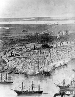
Flag Officer David Farragut led Union naval forces past Confederate defenses and captured New Orleans, the Confederacy's largest city, dealing a devastating blow to Southern control of the Mississippi.
Image source: Capture of New Orleans
May 18, 1863 - Jul 4, 1863
% complete
Ulysses S. Grant's siege and capture of Vicksburg gave the Union full control of the Mississippi River, splitting the Confederacy in two and fulfilling Lincoln's goal that 'the father of waters again goes unvexed to the sea.'
Image source: Siege of Vicksburg
Apr 1838
% complete
Following decades of deadly boiler explosions on Mississippi steamboats, Congress passed the first federal law regulating steam vessels, marking early federal oversight of river commerce and passenger safety.
Image source: Steamboats of the Mississippi
Jan 2, 1900
% complete
Chicago opened its Sanitary and Ship Canal, reversing the Chicago River so it drained away from the Mississippi watershed into Lake Michigan, a massive engineering project meant to protect the river from sewage contamination.
Image source: Chicago Sanitary and Ship Canal
Apr 1927 - Jun 1927
% complete
Levee failures flooded 27,000 square miles across several states, displacing over 600,000 people and killing hundreds. The disaster prompted the landmark Flood Control Act of 1928 and reshaped national flood policy.
Image source: Great Mississippi Flood of 1927
May 15, 1928
% complete
In response to the catastrophic 1927 flood, Congress passed the Flood Control Act, authorizing the Army Corps of Engineers to build an extensive system of levees, spillways, and reservoirs — the Mississippi River and Tributaries Project.
1931
% complete
The Army Corps of Engineers completed the Bonnet Carré Spillway about 33 miles above New Orleans, allowing excess Mississippi floodwaters to divert into Lake Pontchartrain and protecting the city from flooding.
Image source: Bonnet Carré Spillway
1963
% complete
The Old River Control Structure opened in Louisiana to regulate the distribution of Mississippi River flow between the main channel and the Atchafalaya Basin, preventing the river from naturally shifting course and abandoning New Orleans' port.
Image source: Old River Control Structure
1964
% complete
The Army Corps of Engineers completed its series of locks and dams on the upper Mississippi between Minneapolis and St. Louis, begun in the 1930s, maintaining a reliable nine-foot channel for barge navigation year-round.
Image source: List of locks and dams of the Upper Mississippi River
Oct 18, 1972
% complete
The Clean Water Act established national standards for water quality, driving cleanup efforts along industrial stretches of the Mississippi and beginning long-term restoration of the river's ecological health.
Image source: Clean Water Act
Jul 1993 - Aug 1993
% complete
Months of heavy rain produced record flooding along the upper Mississippi and Missouri rivers, inundating towns across nine states, causing billions in damage, and prompting renewed debates about levee policy and floodplain management.
Image source: Great Flood of 1993
1995
% complete
Scientists documented an expanding hypoxic 'dead zone' in the Gulf of Mexico caused largely by agricultural nutrient pollution carried by the Mississippi and Atchafalaya rivers, spurring ongoing efforts to reduce fertilizer runoff throughout the basin.
Image source: Dead zone (ecology)
Aug 29, 2005
% complete
Hurricane Katrina's storm surge overwhelmed levees and floodwalls near the Mississippi's outlet, devastating New Orleans and coastal Louisiana and triggering a massive redesign of the region's hurricane protection system.
Image source: Hurricane Katrina
Aug 2012 - Dec 2012
% complete
A severe Midwest drought dropped Mississippi levels so low that barge traffic nearly stopped south of St. Louis, threatening billions in commerce and highlighting the river's vulnerability to climate extremes.
Image source: 2012–2013 North American drought
Oct 2021 - Nov 2022
% complete
Extreme droughts repeatedly pushed Mississippi River levels to historic lows, exposing sandbars, grounding barges near Memphis, and forcing dredging operations, underscoring growing climate pressures on the nation's most important inland waterway.
Or browse the full history timeline directory, with more than 2,000 topics.
This History of the Mississippi River timeline was generated with the help of AI, using information found on the internet.
We work hard to keep these timelines accurate, but mistakes do get through. If you spot one, email us at [email protected] and we'll fix it for future visitors.
Generate yours with AI or build it from scratch, for free.
Export your timeline, add your own events, edit or remove AI-generated events, and much more
No credit card required.
Cancel anytime.
Cancel anytime.
You can create an unlimited number of timelines with up to 10 events on each one, customize how they look, export them to PDF, PNG, PowerPoint, CSV, and Excel, and share them with a link. Paid plans raise the event limit and add features like spreadsheet imports and collaborators.
Yes. You can cancel your subscription from your account page at any time, and you will not be charged again. Your subscription stays active for the rest of the period you already paid for.
Yes. We will email you a reminder before the annual renewal, and we will also email you a receipt.
Yes. You can email us within 15 days of any payment, and we will issue you a full refund.
Check out our pricing docs or send us an email anytime: [email protected].